ZL190PLUS Handheld GPS for Surveying, High Precision Land
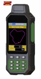
ZL190PLUS Handheld GPS for Surveying, High Precision Land Surveying Equipment, Land Surveyors Tools, Handheld Land Measuring tool for Forest Farmland Mountain Mining Lake HIGH PRECISION ACCURACY: Great support 4 navigation satellite system,GPS+BEIDOU+GLONASS+QZSS ,strong satellite signal,area measurement error in 0.002 acres 3.2'' LARGE SCREEN: Equipped with TFT backlight display, the measurement results can be displayed on the screen clearly, convenient for observation 5 IN 1 MEASUREMENT: The area of any terrain (gardens, parking lots, pastures and flat lands) can be measured, curve line distance and slope can be measured DURABLE DESIGN: IP67 waterproof strong dust-proof function.Portable design, fits in your hand...